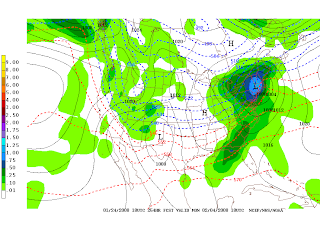
Yes, Friday we will have to deal with a storm that delivers a variety of precipitation. Right now, it looks like the precipitation will start as an icy mix in the late morning. Sometime in the early afternoon, the precipitation will change to all rain. But, there already could be a thick glaze on the roads, trees, and power lines. This may affect school. By dinnertime, there will be a break in the rainfall. Unfortunately, heavy rain will redevelop after 10PM. Do not be surprised if a rumble or two of thunder shakes you awake!
Thursday, January 31, 2008
Monday, January 28, 2008
Upcoming Major Storms: Rain or Snow?
Many storm systems will track through our region in the first part of February; each next one delivering more "frozen" precipitation than rain. Keep in mind: when storms start as rain and quickly change to "frozen" precipitation, the roads have a great chance to freeze into a glacier of ice. Eventually, we may have a nice, full-blown, "big daddy" snowstorm on our hands. Don't worry, as I will be sure to deliver you the most up-to-date and accurate storm data.

Second Storm Potential: Rain to Snow
February 5-6, 2008:

Third Storm Potential: Mainly Snow
February 8-9, 2008:

Forecast Prepared By Tyler Jankoski at 7:27 PM 0 comments
Sunday, January 27, 2008
Observations: Cape Cod & Islands BLIZZARD

Anyone who lives on Cape Cod or the Islands, please email me at tyler@tylersweather.com with snowfall totals and pictures if possible.
Forecast Prepared By Tyler Jankoski at 10:59 PM 0 comments
WINTER STORM WARNING: Cape Cod & Islands BLIZZARD
From the NWS:
THE NATIONAL WEATHER SERVICE IN TAUNTON HAS ISSUED A WINTER STORM
WARNING...WHICH IS IN EFFECT UNTIL 7 AM EST MONDAY. THE SNOW
ADVISORY IS NO LONGER IN EFFECT.
THE WARNING INCLUDES ALL OF CAPE COD AND THE ISLANDS AS WELL AS
COASTAL PLYMOUTH COUNTY.
TRAVEL ON CAPE COD IS NOT RECOMMENDED UNLESS ABSOLUTELY NECESSARY.
FOLLOW THE ADVICE OF LOCAL OFFICIALS.
SNOW WILL CONTINUE AT VARYING RATES ACROSS CAPE COD AND THE ISLANDS
AS WELL AS SOUTHEAST PLYMOUTH COUNTY MASSACHUSETTS THROUGH MIDNIGHT...THEN
SLOWLY EASE DURING THE EARLY MORNING HOURS.
THE COMBINATION OF HEAVY SNOW AND WIND DRIVEN BLOWING SNOW WILL AT
TIMES MAKE NEAR BLIZZARD CONDITIONS IN THE WARNING AREA.
THE PRIMARY TARGET IS CAPE COD WHERE A FOOT OF SNOW WILL OCCUR IN
SOME SPOTS WHILE MANY OTHER AREAS HAVE STORM TOTALS AROUND 5 OR 6
INCHES.
DRIFTS OF 3 TO 4 FEET WILL OCCUR FROM SOUTHEAST PLYMOUTH COUNTY
ACROSS CAPE COD.
TRAVEL MAY BECOME IMPASSABLE AT TIMES TONIGHT DUE TO THE SEVERITY OF
THE BLOWING AND DRIFTING SNOW.
STORM TOTALS IN SOUTHEAST PLYMOUTH COUNTY...MARTHA VINEYARD AND
NANTUCKET WILL PROBABLY AVERAGE BETWEEN 4 AND 8 INCHES.
EVEN WHEN THE SNOW DIMINISHES AFTER MIDNIGHT...OCCASIONALLY SEVERE BLOWING
AND DRIFTING WILL CONTINUE INTO THE MONDAY MORNING DAYLIGHT HOURS...
ESPECIALLY FROM PROVINCETOWN TO WELLFLEET...CHATHAM AND HYANNIS AS
WELL AS NANTUCKET.
Forecast Prepared By Tyler Jankoski at 8:58 PM 0 comments
Storm Moving In: Cape Cod & Islands BLIZZARD
Forecast Prepared By Tyler Jankoski at 11:42 AM 0 comments
Saturday, January 26, 2008
Update: Cape Cod & Islands BLIZZARD
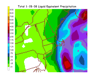
Here is my latest snowfall map for the 1-28-08 winter storm.
Forecast Prepared By Tyler Jankoski at 9:26 PM 0 comments
Update: Cape Cod & Islands BLIZZARD
The biggest winter storm (possibly blizzard) of the season will mainly impact Cape Cod, Nantucket, and Martha's Vineyard late on Sunday and into Monday. Schools will likely be canceled on Monday.The precipitation will start as a mixture of rain, sleet, and snow for many. However, it will quickly change to all snow as the intensity of the precipitation increases. Total Snow Accumulations for this event will range from 3-6" on the islands, but more if less mixing occurs as the storm pulls away. On the Cape, as much as 6-10" could accumulate before the storm leaves on Monday. Some mixing will occur at the end. Click on my snowfall map below to enlarge and get your hometown forecast.
Sustained winds will be between 20MPH and 30MPH at the start of the storm.
Sustained winds will be between 30MPH and 50MPH during the bulk of the storm.
Frequent gusts on the Islands of 60MPH+ are not out of the question.
Blizzard Criteria:
A Blizzard Warning will be issued when the following conditions are forecast to last at least 3 hours. Falling and/or blowing snow frequently reducing visibility to below one-quarter mile, AND sustained winds or frequent gusts of/or over 35 mph.
Forecast Prepared By Tyler Jankoski at 2:19 PM 1 comments
Friday, January 25, 2008
Weekend Outlook
Saturday: Mostly sunny and still cold. High 28 : Low 15
Sunday: Mostly cloudy, a period of light snow possible. High 32 : Low 21
Forecast Prepared By Tyler Jankoski at 5:38 PM 2 comments
Potential: Cape Cod & Islands BLIZZARD
There is a great potential for a colossal snowstorm on Cape Cod, MA and the islands on Sunday night through Monday. Also, the storm will stall a bit while the heavy snow is falling. Very heavy accumulations are possible - watch for further updates!
Forecast Prepared By Tyler Jankoski at 4:07 PM 0 comments
Thursday, January 24, 2008
Frigid Friday Forecast!
Be prepared to deal with harsh weather conditions on Friday. The high temperature will range from 26-27 degrees, but not after a bitter morning low of 12-13 degrees. The skies will be mostly sunny to partly cloudy.
It will feel like 2 degrees in the morning, with 5-10MPH winds!
Be bundled up!
Forecast Prepared By Tyler Jankoski at 9:33 PM 0 comments
Any 6"+ Winter Storms in Sight?
Forecast Prepared By Tyler Jankoski at 7:08 PM 0 comments


